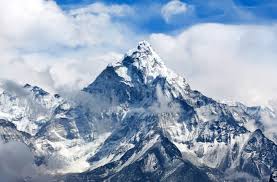
 PTI (Beijing, 12 February 2018) – China continues to differ with Nepal over the height of Mount Everest and sticks to its own calculation of the world’s highest peak which is four meters less than the Kathmandu’s measurement, a media report said today.
China’s response came after reports said that Beijing had agreed to accept Nepal’s measurement of the mountain, which is almost four meters taller.
The Chinese official media has contradicted the recent The New York Times report that China had recognised the mountain’s height as 8,848 meters, quoting Ang Tshering Sherpa, the former head of the Nepal Mountaineering Association.
China has not changed its measurement of the height of Mount Qomolangma, the Chinese name of the Mt Everest, which stands at 8844.43 meters, state-run Global Times reported.
China recognises Mount Qomolangma as the world’s tallest, measuring 8,844.43 meters above sea level, the National Administration of Surveying, Mapping and Geo-information (NASG) told the state-run Xinhua News Agency.
The peak of Mt Everest played a significant role in the settlement of boundary between Nepal and China, which earlier claimed the whole mountain as part of its territory after it took control of Tibet.
But it was finally settled in 1961 after the intervention of the ruling Communist Party of China (CPC) founder Mao Zedong, who suggested that the boundary line should pass through the summit of the Mt Everest, which was agreed by Nepal.
More and more international climbers are reportedly using the Tibetan side of the Mt Everest as China has improved facilities compared to Nepal.
In 2005, the NASG measured Mt Everest’s rock base at 8844.43 meters above sea level. The depth of the snow on the mountain top was measured at 3.5 meters.
The NASG said that China had never in any form said it has changed the 2005 result, which has been authorised by the central cabinet and released to the public in accordance with relevant regulations.
According to the NASG, the standard height of the mountain is important data for China and international research on mapping, geosciences, environment and climate change and it also showcases comprehensive national strength.
“Each country’s surveyors have the intention of making others recognise their own measurements and their own outcome. But the different heights come from different measurement methods,” Zhao Kangning, former deputy director of China’s National Administration of Global Navigation Satellite Systems and Applications, told the Global Times.
“The different measurements of Mount Qomolangma’s height between China and Nepal is a competition over the mountain,” Xu Jianying, a research fellow of Research Centre for Chinese Borderland History and Geography at the Chinese Academy of Social Sciences (CASS) said.
However, Li Guoqiang, another expert at CASS, said that “the dispute over the height of Mt Qomolangma should not be politicised.”